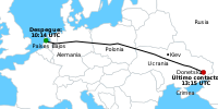
File:MH17 map-es.svg
| Uploaded by | Ezarate |
|---|---|
| Upload date | 2014-07-17T22:12:54Z |
| MIME type | image/svg+xml |
| Dimensions | 512 × 256 px |
| File size | 233.5 KB |
Summary
| Description |
Español: Mapa de vuelo del vuelo 17 de Malasya Airlines |
| Date | 10:57, Thursday July 30, 2026 (UTC) |
| Source | File:MH17 map.svg |
| Author | Geordie Bosanko and Cmglee, traducido por Ezarate |
| Other versions |
[] English: Base maps
English: Other maps
|
| SVG development |


Licensing


This file is licensed under the Creative Commons Attribution-Share Alike 3.0 Unported license.
- You are free:
- to share – to copy, distribute and transmit the work
- to remix – to adapt the work
- Under the following conditions:
- attribution – You must give appropriate credit, provide a link to the license, and indicate if changes were made. You may do so in any reasonable manner, but not in any way that suggests the licensor endorses you or your use.
- share alike – If you remix, transform, or build upon the material, you must distribute your contributions under the same or compatible license as the original.