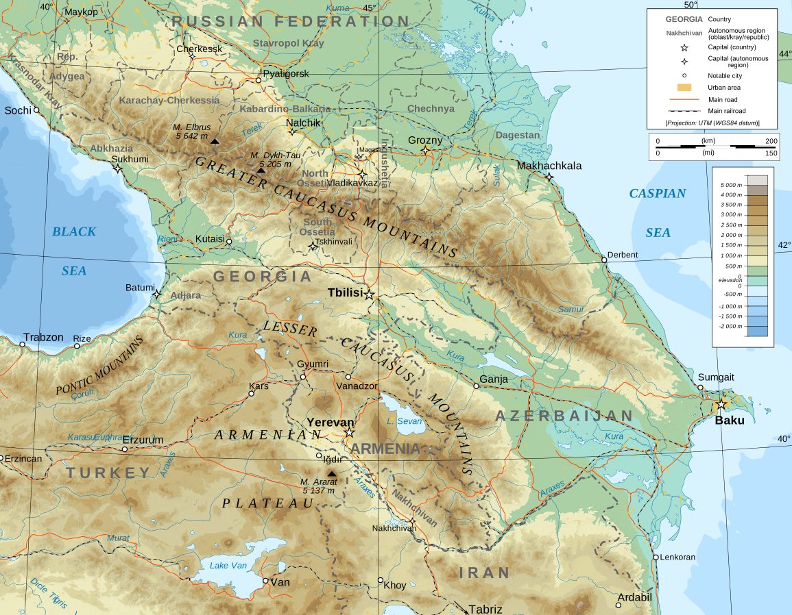
File:Caucasus topographic map-en.svg
| Uploaded by | Toghrul R |
|---|---|
| Upload date | 2025-01-20T19:20:03Z |
| MIME type | image/svg+xml |
| Dimensions | 1155 × 898 px |
| File size | 5.6 MB |
Summary
| Description |
English: Topographic map of the Caucasus in English |
| Date | |
| Source |
English: Own work ; Topographic data from the NASA Shuttle Radar Topography Mission (SRTM3 v.2) (public domain) edited with 3DEM, reprojected in UTM with GDAL (GDAL), and vectorized with Inkscape ; UTM projection ; WGS84 datum ; shaded relief (composite image of N-W, W and N lightning positions) ; Reference used for the additional data : * Rivers, cities, railroads, routes, bathymetry : Demis add-on for World Wind (see the approval e-mail and the Demis forum) ; * Borders and coast : World data bank II ; Approximate scale of topographic data : 1:1,463,000 ; Note : The shaded relief is a raster image embedded in the SVG file. Approximate geographic limits of the map (3' close) : * SW corner : 38°05'00"N – 39°33'00"E * SE corner : 38°05'00"N – 51°00'00"E * NE corner : 45°00'00"N – 51°00'00"E * NW corner : 45°00'00"N – 39°00'00"E |
| Author | Bourrichon - fr:Bourrichon with English translations, additions, and corrections by Ketone16 (partly following Yuri Koryakov) |
| Permission (Reusing this file) |
GFDL / Attribution and Share-Alike required |
| Other versions |
|


Licensing
I, the copyright holder of this work, hereby publish it under the following licenses:

|
Permission is granted to copy, distribute and/or modify this document under the terms of the GNU Free Documentation License, Version 1.2 or any later version published by the Free Software Foundation; with no Invariant Sections, no Front-Cover Texts, and no Back-Cover Texts. A copy of the license is included in the section entitled GNU Free Documentation License. |


This file is licensed under the Creative Commons Attribution-Share Alike 4.0 International, 3.0 Unported, 2.5 Generic, 2.0 Generic and 1.0 Generic license.
- You are free:
- to share – to copy, distribute and transmit the work
- to remix – to adapt the work
- Under the following conditions:
- attribution – You must give appropriate credit, provide a link to the license, and indicate if changes were made. You may do so in any reasonable manner, but not in any way that suggests the licensor endorses you or your use.
- share alike – If you remix, transform, or build upon the material, you must distribute your contributions under the same or compatible license as the original.
You may select the license of your choice.
Category:CC-BY-SA-4.0,3.0,2.5,2.0,1.0
Category:English-language SVG maps of Asia
Category:English-language SVG maps of Europe
Category:GFDL
Category:License migration redundant
Category:Maps showing the whole Caucasus
Category:SVG topographic maps of Armenia
Category:SVG topographic maps of Azerbaijan
Category:SVG topographic maps of Georgia (country)
Category:Self-published work
Category:Topographic maps of the Caucasus