File:Colonisation 1812.png
Uploaded by M.Bitton
Upload date 2022-03-17T23:54:19Z
MIME type image/png
Dimensions 1357 × 628 px
File size 15.8 KB

Summary

Description
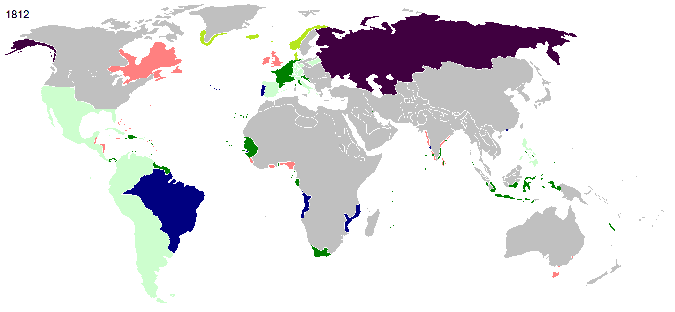
English: Colonial empires in 1812
Français : Empires coloniaux en 1812
Español: Imperios coloniales en 1812
Português: Impérios Coloniais em 1812
 
Britain
 
French Empire
 
French satellite states
 
Russia
 
Denmark
 
Portugal
 
others
Maps of world history
BC

5000 · 2000 · 1000 · 500 · 400 · 323 · 300 · 200 · 100 · 50


AD

1 · 50 · 100 · 200 · 250 · 300 · 400 · 500 · 700 · 750 · 820 · 900 · 1200 · 1500 · 1556 · 1648 · 1700 · 1750 · 1815 · 1859 · 1871 · 1914 · 1935 · 1954 · 1989 · 2000 ·


Maps of colonization history
1492 · 1550 · 1600 · 1660 · 1754 · 1800 · 1812 · 1822 · 1885 · 1898 · 1914 · 1920 · 1936 · 1938 · 1945 · 1959 · 1974 · 1975 · 2007
Animated Map

Maps of Cold War
1959 · 1980 · Nows ·

see also: Eastern Hemisphere only maps template (1300BC-1500AD)

(this template: · view · discuss )
Date
Source Own work
Author Hruska
Permission
(Reusing this file)
Public domain I, the copyright holder of this work, release this work into the public domain. This applies worldwide.
In some countries this may not be legally possible; if so:
I grant anyone the right to use this work for any purpose, without any conditions, unless such conditions are required by law.
Other versions
This file has been superseded by French Empire on World 1812.png. It is recommended to use the other file. Please note that deleting superseded images requires consensus.
new file
This historical map image could be re-created using vector graphics as a SVG file. This has several advantages; see Commons:Media for cleanup for more information. If a SVG form of this image is available, please upload it and afterwards replace this template with {{vector version available|new image name}}.
It is recommended to name the SVG file “Colonisation 1812.svg”—then the template Vector version available (or Vva) does not need the new image name parameter.

Licensing

Public domain I, the copyright holder of this work, release this work into the public domain. This applies worldwide.
In some countries this may not be legally possible; if so:
I grant anyone the right to use this work for any purpose, without any conditions, unless such conditions are required by law.

Captions

Add a one-line explanation of what this file represents

Items portrayed in this file

depicts

image/png

b231e79b800e977a4e6046f2d27207e65ac801c5

16,180 byte

628 pixel

1,357 pixel

Category:Historical map images that should use vector graphics Category:Maps of the world in the 19th century Category:Maps showing the history of colonies Category:PD-self Category:PNG that should use vector graphics Category:Self-published work Category:Superseded