File:Modern Levant.PNG
| Uploaded by | DeusVultInfidels |
|---|---|
| Upload date | 2019-12-31T23:52:12Z |
| MIME type | image/png |
| Dimensions | 554 × 370 px |
| File size | 45.5 KB |
Summary
| Description |
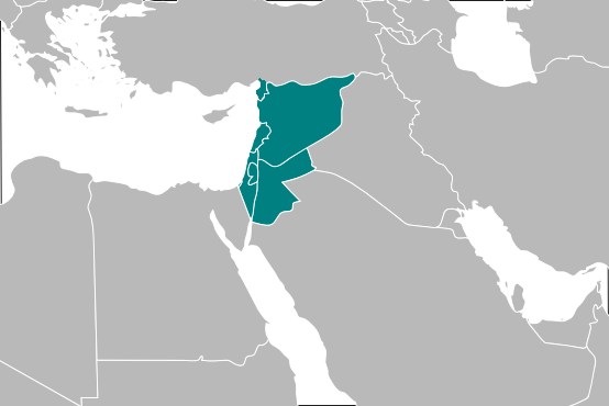
العربية: بلادالشام في وقتنا الحاضر.
བོད་ཡིག: ལའེ་ཧྥན་ཐ།.
English: Levant.
Español: El país de Sham.
Français : Le Levant dans ses frontières modernes, comprenant Liban, Syrie, Jordanie, Israël et Territoires palestiniens.
Lietuvių: Šiuolaikinis Levantas.
Português: O País de Sham.
ไทย: บริเวณที่เรียกว่าลว้านปัจจุบันที่ประกอบด้วยจอร์แดน, เลบานอน, อิสราเอล, ดินแดนปาเลสไตน์และซีเรีย.
中文:沙姆地区地图. |
|||
| Date | 26 March 2006 (original upload date) | |||
| Source | Transferred from en.wikipedia to Commons. | |||
| Author | SpLoT at English Wikipedia | |||
| Other versions |
|


Licensing

|
This work has been released into the public domain by its author, SpLoT at English Wikipedia. This applies worldwide. In some countries this may not be legally possible; if so: SpLoT grants anyone the right to use this work for any purpose, without any conditions, unless such conditions are required by law. |
Original upload log
The original description page was here. All following user names refer to en.wikipedia.

- 2006-03-26 04:02 SpLoT 443×396×8 (15523 bytes) {{PD-self}}