File:Fascist occupation of yugoslavia.png
 |
File:Map of the Axis occupation of Yugoslavia.svg is a vector version of this file. It should be used in place of this PNG file when not inferior.Category:Vector version available
File:Fascist occupation of yugoslavia.png → File:Map of the Axis occupation of Yugoslavia.svg (by User:Amitchell125)
For more information, see Help:SVG. |
 |
Summary
| Description |
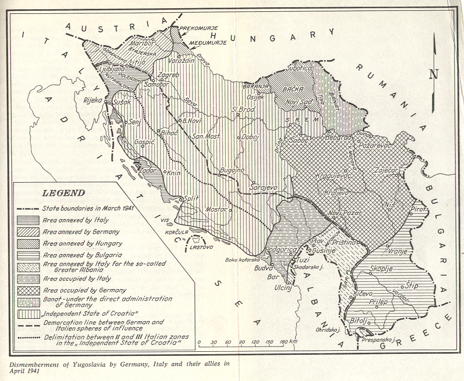
English: Axis / Fascist occupation and partition of Yugoslavia in World War II (as of 1941). Srpskohrvatski / српскохрватски: Fašistička okupacija i rasparčavanje Jugoslavije u Drugom svetskom ratu (1941. godine). |
| Source | Own work |
| Author | WikiEditor2004 |
| Other versions |
|


Licensing
self-made map by WikiEditor2004
| I, the copyright holder of this work, release this work into the public domain. This applies worldwide. In some countries this may not be legally possible; if so: I grant anyone the right to use this work for any purpose, without any conditions, unless such conditions are required by law. |
References
- Istorijski atlas, Geokarta, Beograd, 1999.
- Školski istorijski atlas, Zavod za izdavanje udžbenika SR Srbije, Beograd, 1970.
- Povijesni atlas, Učila - Zagreb, Zagreb, 1971.
- Denis Šehić - Demir Šehić, Istorijski atlas sveta, Beograd, 2007.
- The Times History of Europe, Times Books, London, 2002.
- Richard Overy, The Times History of the 20th Century, Times Books, London, 2004.
- The Times Atlas svjetske povijesti, Cankarjeva založba, Ljubljana - Zagreb, 1986.
- Tim Džuda, Srbi - istorija, mit i razaranje Jugoslavije, Beograd, 2003.
- Džon R. Lempi, Jugoslavija kao istorija, Beograd, 2004.
- Fransisko Veiga, Balkanska zamka (1804-2001), Beograd, 2003.
- Dr Tomislav Bogavac, Nestajanje Srba, Niš, 1994.
- Valter Manošek, Holokaust u Srbiji, Beograd, 2007.
- http://www.terra.es/personal7/jqvaraderey/194145fc.gif
- http://www.svetskirat.net/slike/razbijanje/zazbijanje_jugoslavije_1941.jpg
- http://www.marxists.org/subject/yugoslavia/images/maps/1941-dismemberment.jpg
- http://www.ushmm.org/lcmedia/map/lc/image/yug71020.gif
- http://www.srpska-mreza.com/MAPS/Yugoslavia/YU-Nazi-division.jpg archive copy at the Wayback Machine
- http://www.cartoko.com/content/wp-content/uploads/2010/05/Yugoslavia_1992_p038_CtryStudy.jpg%5Bdead+link%5D
- http://www.arhivyu.gov.rs/Data/Images/06_karta_b.jpg archive copy at the Wayback Machine
- http://terkepek.adatbank.transindex.ro/kepek/netre/211.gif archive copy at the Wayback Machine
Category:Maps of Montenegro during World War II
Category:Maps of Serbia during World War II
Category:Maps of World War II in Slovenia
Category:Maps of the Axis occupation of Yugoslavia
Category:Maps of the Independent State of Croatia
Category:Maps of the history of Banat
Category:PD-self
Category:Self-published work
Category:Vector version available