File:Gz-mapa.png
| Uploaded by | Kordas |
|---|---|
| Upload date | 2007-12-02T02:12:21Z |
| MIME type | image/png |
| Dimensions | 328 × 352 px |
| File size | 20.3 KB |
Summary
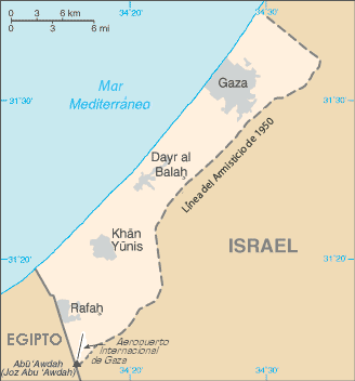
Español: Mapa de la Franja de Gaza.
Translated to spanish from Image:Gz-map.png by Sanbec

|
File:Mapa de la Franja de Gaza.svg is a vector version of this file. It should be used in place of this PNG file when not inferior.
File:Gz-mapa.png → File:Mapa de la Franja de Gaza.svg
For more information, see Help:SVG. |
 |
[]
Ver1:
-

-
 Deutsch (png)
 -
 norsk (png)
 -
 polski
 -
 Türkçe (png)
 -
 Ελληνικά
 -
 العربية (png)
 -
 العربية


Ver2:
-
 català
 -
 English
 -
 español
 -
 euskara
 -
 français
 -
 Gaeilge
 -
 hrvatski
 -
 Bahasa Indonesia
 -
 italiano
 -
 magyar
 -
 Nederlands
 -
 polski
 -
 português
 -
 română
 -
 Ελληνικά
 -
 македонски
 -
 русский
 -
 српски (ћирилица)
 -
 українська
 -
 한국어
한국어 -
 中文
中文 -
 עברית
עברית -
 العربية
 -
 فارسی
فارسی


External links
- Gaza Strip archive copy at the Wayback Machine from CIA factbook

|
This work is in the public domain in the United States because it is a work prepared by an officer or employee of the United States Federal Government as part of that person’s official duties under the terms of Title 17, Chapter 1, Section 105 of the US Code.
Note: This only applies to original works of the Federal Government and not to the work of any individual U.S. state, territory, commonwealth, county, municipality, or any other subdivision. This template also does not apply to postage stamp designs published by the United States Postal Service since 1978. (See § 313.6(C)(1) of Compendium of U.S. Copyright Office Practices). It also does not apply to certain US coins; see The US Mint Terms of Use.
|
 |
| This file has been identified as being free of known restrictions under copyright law, including all related and neighboring rights. | ||