File:Armeniamap3.jpg
Summary
| Description |
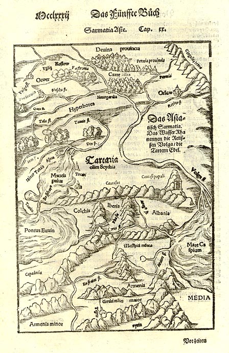
English: Ptolemy's 3rd Asian Map, showing Tartaria = Scythia, Hyperborea, Armenia maior, Armenia minor, Syria, Pontus Euxinus, Taurica, Volga flumen, Colchis, Iberia, Albania, Media, Capadocia, etc. Detailed map of the region from the Volga and the Caspian to the Black Sea, extending North of the Caucus Mountains to Deuina and Uglitz. Also shows the Don and the Euphrates. Munster's Cosmography was one of the most influential geographical works of the 16th Century. It was published in a number of editions over a half century and was continuously revised and updated to include new illustrations and updated information. |
|||||||||||||||||||||||
| Date | ||||||||||||||||||||||||
| Source | www.armenica.org – file | |||||||||||||||||||||||
| Author |
|
|||||||||||||||||||||||
| Other versions |
|
|||||||||||||||||||||||
.jpg)

_Себастьян_Мюнстер_1544г_Базель_по_материалам_Сигизмунда_Герберштейна_Гравюра_на_дереве.gif)

Licensing
|
This is a faithful photographic reproduction of a two-dimensional, public domain work of art. The work of art itself is in the public domain for the following reason:
The official position taken by the Wikimedia Foundation is that "faithful reproductions of two-dimensional public domain works of art are public domain". This photographic reproduction is therefore also considered to be in the public domain in the United States. In other jurisdictions, re-use of this content may be restricted; see Reuse of PD-Art photographs for details. | ||||
Category:1570s maps of the Caucasus
Category:16th-century maps of Tartary
Category:CC-PD-Mark
Category:Illustrations of Cosmographia (Münster)
Category:Old maps from armenica.org
Category:Old maps of Ptolemaic Sarmatia
Category:PD-Art (PD-old-auto-expired)
Category:PD-old-100-expired
Category:Ptolemy's 3rd Asian Map