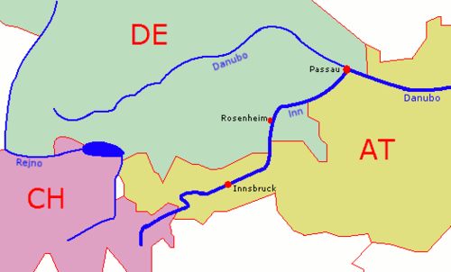
River Inn

river in Switzerland, Austria and Germany, a right tributary of the Danube  Řeka na dolním toku  | |||||
| Upload media | |||||
| Pronunciation audio | ⓘ | ||||
|---|---|---|---|---|---|
| Instance of | |||||
| Location |
| ||||
| Length |
| ||||
| Origin of the watercourse | |||||
| Mouth of the watercourse | |||||
| Drainage basin | |||||
| Basin country | |||||
| Tributary |
| ||||
| Lake on watercourse | |||||
| Different from | |||||
 Category:Uses of Wikidata Infobox with maps Category:Uses of Wikidata Infobox with maps | |||||
| |||||

 Inntal-Radweg, cycling trail
 Inntal mit Karwendelgebirge (Alps) bei Jenbach
 Eiszeitlich geformtes Inntal bei Jenbach mit Hang zum höher gelegenen Achenseetal
 Fluss mit Siedlungsraum und Verkehrswegen bei Schwaz, Vomp,


 Lunghinsee (En), Hauptwasserscheide am
 Lunghin Drainage divide, near source of Inn
 Engadiner-Seenplatte bei St. Moritz, Engadin
 Der Inn bei Lavin (Zernez) im Unterengadin
 Blick vom Dreiländerpunkt A-IT-CH (photo) auf den En und die Innschlucht bei Valsot.
 Oberinntal bei Landeck (Tirol) und Imst, Seitenstromtäler des Inn-Gletschers Richtung Loisach. ISS-Foto mit Mouseover-AnmerkungenEnglish: Region of former Inn Glacier, valley Gurgltal, Imst and Innsbruck. Alps, photo.
 Oberinntal bei Telfs und Wildermieming. Weiter talabwärts Innsbruck.English: View downstreams to Innsbruck
 Unterinntal bei Wörgl
 Europareservat Unterer Inn


Category:Gallery pages about rivers in Austria
Category:Gallery pages about rivers in Bavaria
Category:Gallery pages about rivers in Switzerland
Category:Gallery pages of Lower Bavaria
Category:Gallery pages of Upper Bavaria
Category:Inn River
Category:Pages using the Phonos extension
Category:Pages with coordinates
Category:Uses of Wikidata Infobox
Category:Uses of Wikidata Infobox with maps