File:Radar-height.PNG

Uploaded by Pierre cb
Upload date 2006-05-08T15:26:36Z
MIME type image/png
Dimensions 649 × 487 px
File size 43.6 KB

Summary

Description
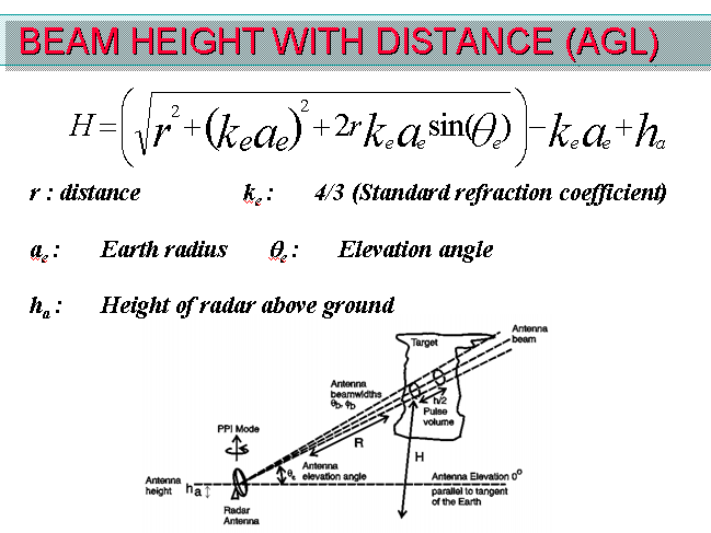
English: Calculation of height above ground of a radar beam.
Date
Source Own work
Author Pierre cb
Other versions

Derivative works of this file:

Licensing

I, the copyright holder of this work, hereby publish it under the following license:
GNU head Permission is granted to copy, distribute and/or modify this document under the terms of the GNU Free Documentation License, Version 1.2 or any later version published by the Free Software Foundation; with no Invariant Sections, no Front-Cover Texts, and no Back-Cover Texts. A copy of the license is included in the section entitled GNU Free Documentation License.
w:en:Creative Commons
attribution share alike
This file is licensed under the Creative Commons Attribution-Share Alike 3.0 Unported license.
You are free:
  • to share – to copy, distribute and transmit the work
  • to remix – to adapt the work
Under the following conditions:
  • attribution – You must give appropriate credit, provide a link to the license, and indicate if changes were made. You may do so in any reasonable manner, but not in any way that suggests the licensor endorses you or your use.
  • share alike – If you remix, transform, or build upon the material, you must distribute your contributions under the same or compatible license as the original.
This licensing tag was added to this file as part of the GFDL licensing update.

Captions

Add a one-line explanation of what this file represents

Items portrayed in this file

depicts

8 May 2006

44,673 byte

487 pixel

649 pixel

image/png

c88f26aee31641416d9867926c69e0b11169d692

Category:CC-BY-SA-3.0-migrated Category:Files with derivative versions Category:GFDL Category:License migration completed Category:Radar beam height in normal propagation Category:Self-published work