Louisiana
States of the United States: Alabama · Alaska · Arizona · Arkansas · California · Colorado · Connecticut · Delaware · Florida · Georgia · Hawaii · Idaho · Illinois · Indiana · Iowa · Kansas · Kentucky · Louisiana · Maine · Maryland · Massachusetts · Michigan · Minnesota · Mississippi · Missouri · Montana · Nebraska · Nevada · New Hampshire · New Jersey · New Mexico · New York · North Carolina · North Dakota · Ohio · Oklahoma · Oregon · Pennsylvania · Rhode Island · South Carolina · South Dakota · Tennessee · Texas · Utah · Vermont · Virginia · Washington · West Virginia · Wisconsin · Wyoming – District of Columbia: Washington, D.C.
insular area of the United States: American Samoa · Guam · Northern Mariana Islands · Puerto Rico · United States Virgin Islands – United States Minor Outlying Islands: Baker Island · Howland Island · Jarvis Island · Johnston Atoll · Kingman Reef · Midway Atoll · Navassa Island · Palmyra Atoll · Wake Island
insular area of the United States: American Samoa · Guam · Northern Mariana Islands · Puerto Rico · United States Virgin Islands – United States Minor Outlying Islands: Baker Island · Howland Island · Jarvis Island · Johnston Atoll · Kingman Reef · Midway Atoll · Navassa Island · Palmyra Atoll · Wake Island
state of the United States of America  Fontainebleau State Park in Louisiana across Lake Pontchartrain from New Orleans      | |||||
| Upload media | |||||
| Pronunciation audio | ⓘ | ||||
|---|---|---|---|---|---|
| Instance of | |||||
| Part of | |||||
| Named after | |||||
| Location |
| ||||
| Located in or next to body of water | |||||
| Capital |
| ||||
| Legislative body | |||||
| Executive body | |||||
| Highest judicial authority | |||||
| Anthem |
| ||||
| Head of government |
| ||||
| Inception |
| ||||
| Highest point | |||||
| Population |
| ||||
| Area |
| ||||
| Elevation above sea level |
| ||||
| Replaces | |||||
| Different from | |||||
| Maximum temperature record |
| ||||
| Minimum temperature record |
| ||||
| official website | |||||
 Category:Uses of Wikidata Infobox with maps Category:Uses of Wikidata Infobox with maps | |||||
| |||||
Symbols - Symboles
 Flag
Flag
Drapeau Seal
Seal
Sceau


Maps - Cartes
 The Louisiana Purchase of 1803
La vente de la Louisiane en 1803 1814 map of Louisiana
Carte de la Louisiane dâtant de 1814 1921 map of Louisiana
Carte de la Louisiane dâtant de 1921


.jpeg)


Photos
 Madewood Plantation House
 The Hammond Oak in Hammond, La.
Le chêne de Hammond à Hammond, en Louisiane. The Lake Pontchartrain Causeway
La route du lac Pontchartrain superdome
 Downtown Lake Charles
Centre-ville de Lac Charles Bald Cypress in the swamps of southern Louisiana
Cyprès chauve dans les bayoux du sud de la Louisiane Bald Cypress Swamp
Cyprès chauve dans un bayou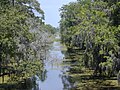 Kenta Canal at Barataria Preserve
Le canal Kenta dans la réserve de Barataria Marshland at Barataria Preserve
Marais dans la réserve de Barataria Cemetery in the village of Lafitte
Le cimetière du village de Lafitte,


