User talk:Ecrusized
|
Our first steps tour and our frequently asked questions will help you a lot after registration. They explain how to customize the interface (for example the language), how to upload files and our basic licensing policy (Wikimedia Commons only accepts free content). You don't need technical skills in order to contribute here. Be bold when contributing and assume good faith when interacting with others. This is a wiki. More information is available at the community portal. You may ask questions at the help desk, village pump or on IRC channel #wikimedia-commons (webchat). You can also contact an administrator on their talk page. If you have a specific copyright question, ask at the copyright village pump. |
|
-- Wikimedia Commons Welcome (talk) 10:59, 22 April 2021 (UTC)
translate
Hi, can I we get October 2023 Gaza−Israel conflict.png and any new maps of the situation with no text for translating it?
Thank you for creating those maps, They are really good. אורי9 (talk) 07:38, 11 October 2023 (UTC)
- @אורי9: Thank you. You can use the svg translate tool, https://svgtranslate.toolforge.org/ to translate and upload the file. This way the file will be translated automatically even after updates. Ecrusized (talk) 07:58, 11 October 2023 (UTC)
- Thank you, I did it. But in the Hebrew Wikipedia it seems as if nothing has changed. Do you know why? אורי9 (talk) 08:29, 11 October 2023 (UTC)
- @אורי9: There appears to a be problem translating the file right now. You can participate in this discussion here, File talk:October 2023 Gaza−Israel conflict.svg#Translation. It should be fixed in a couple of hours. Ecrusized (talk) 08:44, 11 October 2023 (UTC)
- The file File:October 2023 Gaza−Israel conflict (7– 8 October).svg does have the option to be translated in the program you sent, but on Wikipedia it still appears in the English language. אורי9 (talk) 08:54, 11 October 2023 (UTC)
- @אורי9: There appears to a be problem translating the file right now. You can participate in this discussion here, File talk:October 2023 Gaza−Israel conflict.svg#Translation. It should be fixed in a couple of hours. Ecrusized (talk) 08:44, 11 October 2023 (UTC)
- Thank you, I did it. But in the Hebrew Wikipedia it seems as if nothing has changed. Do you know why? אורי9 (talk) 08:29, 11 October 2023 (UTC)
- Hey Ecrusized and אורי9, you might want to compare your map with this one from Haaretz for any missing details. Cheers. François Robere (talk) 00:00, 12 October 2023 (UTC)
- @François Robere: Thank you. Ecrusized (talk) 08:17, 12 October 2023 (UTC)
.svg)
Map legend difficult t read
Hi Ecrusized. Would it be possible to rdo the legend section of your map, with a bigger font and preferably without the black background? Regards, Rui Gabriel Correia (talk) 14:01, 13 October 2023 (UTC)
- @Rui Gabriel Correia: I have increased the font size. Ecrusized (talk) 14:58, 13 October 2023 (UTC)
- Thank you; appreciated. Rui Gabriel Correia (talk) 15:03, 13 October 2023 (UTC)-8-
Please edit 7-8 October map to include Zikim military base
Hello User:Ecrusized. Please edit your map of the situation in southern Israel during 7-8 October to include the Zikim military base, which is located near the coastline just west of Zikim village, in the blue area denoting the presence of Palestinian militants. Reference 1, Reference 2. Thank you. SaintPaulOfTarsus (talk) 12:34, 17 October 2023 (UTC)
.svg)
- Done, thanks for providing sources. Ecrusized (talk) 12:45, 17 October 2023 (UTC)
- Thank you, much appreciated. SaintPaulOfTarsus (talk) 02:10, 18 October 2023 (UTC)
your map
Your map is non neutral and false, Golan Heights can not have same color as Israel, it must be separate, Ghajar is also shown as "Evacuated areas inside Israel" when its not in israel and hasn't been evacuated:https://www.ynetnews.com/article/h14owakgt Supreme Deliciousness (talk) 04:36, 25 October 2023 (UTC)
- @Supreme Deliciousness: Ghajar is located in the Israeli controlled Golan Heights. It was included among the settlements ordered to be evacuated by the IDF. I can separate the Golan Heights if preferred. Ecrusized (talk) 07:48, 25 October 2023 (UTC)
- My link shows that it was never evacuated. also, it should be "Israeli-occupied", not "controlled." --Supreme Deliciousness (talk) 14:00, 25 October 2023 (UTC)
- @Supreme Deliciousness: Very well, I've changed the legend to Israeli-occupied. You can see that Ghajar is no longer included in the evacuation zone. Ecrusized (talk) 14:15, 25 October 2023 (UTC)
- Why changing the Golan color in File:Israel-Lebanon-Syria-border-Conflict-2023.svg?
- There has been continuous de jure Israeli sovereignty there since 1981, and de facto Israeli sovereignty even before that. The United States and other countries recognize this sovereignty. אורי9 (talk) 13:43, 29 October 2023 (UTC)
- Area is internationally regarded as part of Syria, not Israel. Any Israeli claimed "sovereignty" is null and void. --Supreme Deliciousness (talk) 03:43, 29 December 2024 (UTC)
- @Supreme Deliciousness: Very well, I've changed the legend to Israeli-occupied. You can see that Ghajar is no longer included in the evacuation zone. Ecrusized (talk) 14:15, 25 October 2023 (UTC)
- My link shows that it was never evacuated. also, it should be "Israeli-occupied", not "controlled." --Supreme Deliciousness (talk) 14:00, 25 October 2023 (UTC)
"Under Palestinian control"?
In File:October 2023 Gaza−Israel conflict.svg, the red color refers to "Gaza Strip under Palestinian control". I ask to change it to "Gaza Strip under Hamas control", for the following reasons:
- We cannot predict the future, there might be rebellions soon.
- The Arabs are not in control in Gaza Strip. This is a Hamas dictatorship that enjoys broad public support, not a government controlled by the public.
fixes
in File:Israel-Lebanon-Syria-border-Conflict-2023.svg:
- "Geshurt" is "Geshur"
- "Afikt" is "Afik"
- "Ani'atm" is "Ani'am"
- "Avtaliont" is "Avtalion"
- "Ayelet tHaShahar" is "Ayelet HaShahar"
- "Rehaniyat" is "Rihaniya"
- "Notift" is "Nofit"
- Merkaz Kah and Yavor are not settlements
- Kibbutz Abirim ("Abirim"), Tuval, Pelekh, Mitzpe Aviv, Ma'ale Tzviya, Lotem, Nimrod, and Shadmot Dvora are not mentioned
- Eshbal is mentioned as part of Eshhar
- Hamdon is Unrecognized village
- Nof HaGalil is a little south-western, in the Latitude of Shibli–Ummal-Ghanam and in the longitude between Reineh and Mashhad
- Why is "Shebaa Farms" mentioned?
Thank you for creating the map. אורי9 (talk) 14:32, 29 October 2023 (UTC)
- @אורי9: Thanks. I've applied the naming fixes and missing names. With regards to your other questions, I initially had Golan Heights colored the same with Israel but user @Supreme Deliciousness: requested to have it separated. There seems to be a dispute regarding how the Golan Heights should be displaced on the map, you can try discussing this with the other user or opening an RfC. I don't have a standpoint on this dispute but I will apply whatever the consensus is on the map. When it comes to naming of "Palestinians", I had considered calling it "militants" (as there are additional groups besides Hamas, such as PIJ etc.) control, but some users may find that in violation of WP:NPOV. You can also try discussing this with other users. Additionally, you can change the names on the file directly by using Inkscape, or any text editor such as Notepad. Ecrusized (talk) 18:48, 29 October 2023 (UTC)
- 1. Thank you. Two more missing names are "Kfar Hasidim Alef" and "Kfar Hasidim Beit", Which are now shown as part of Rekhasim.
- Hay El Maslakh is neighborhood in Bint Jbeil and Wazzani is de facto part of Ghajar.
- 2. About the Golan Heights: The situation is really simple. Golan Heights is Syria according to the UN and some countries and it is Israel according to USA and some other countries.
- Israel is the one who actually controls the territory, and on Wikipedia it is customary to refer to the actual situation.
- 3. The "Palestinians" (What is Palestinian? try to define) in Gaza are controlled only by Hamas. It's truely neutral to say this. The PIJ doesn't control any land.
- I think "militants control" is wrong. Google search for "BBC using militant" will give you the answer why I think that. אורי9 (talk) 20:31, 29 October 2023 (UTC)
- @אורי9: I've applied the naming fixes except Wazzani, according to Open Street Map Wazzani is located on the Lebanese side of the border. And with regards to Golan Heights, again, please discuss this issue with user @Supreme Deliciousness: as they are the one who requested to have it separated. With regards to Gaza, groups like PFLP, DFLP and PIJ apparently operate in the non-Israeli controlled regions. Hence I think it's better to call it Palestinian or Militant controlled, instead of Hamas controlled. Ecrusized (talk) 20:49, 29 October 2023 (UTC)
- Respected User:Ecrusized, with regards to Ghajar and al-Wazzani, I would like to draw your attention to the following:
- Israel has been in control of the entire "divided" village of Ghajar, including areas north of the "Blue Line" border, since 2006.
- United Nations Interim Force in Lebanon, 2021 However, not all violations of the Blue Line are accidental. Some, like Israel’s ongoing occupation of the northern half of the village of Ghajar, are well known and continuous.
- The Guardian, 2022 In 2000, when the IDF withdrew from Lebanon, UN representatives came up with the Blue Line between the countries, leaving Ghajar split into two ... Today a fence runs around the entire village’s perimeter, rather than inside it, and the de facto demarcation line has become the Hasbani River.
- Al-Jazeera, 2023 But during the 34-day war between Israel and the Lebanese Shia group Hezbollah in July 2006, Israel, again, took control of the Lebanese part of Ghajar. And despite Israel agreeing to withdraw from north Ghajar in line with the UN Security Council resolution that ended the fighting, Israel has not yet pulled out. Instead, within years, Israel started building a wall around the northern part of Ghajar.
- Wazzani does not refer to the northern "Lebanese" part of Ghajar, but a different place altogether:
- The Guardian, 2022 [T]he de facto demarcation line has become the Hasbani River, which flows through a small valley between Ghajar and Wazzani, a Lebanese hamlet on the other side.
- Haaretz, 2009 archived here ["T]he village has been divided into two neighborhoods that in 2000 were mistakenly thought to be two different villages - Ghajar in the south and al-Wazzani in the north." He points out that there never was a village by the name of al-Wazzani, but rather "a small community called al-Wazzani, more known as Arab al-Luweiza," which is located across from Ghajar and west of the Hatzbani river.
- With this in mind, I would like to ask you to amend the file in question, to portray Israeli control over northern Ghajar, currently depicted in yellow, and to slightly adjust the position of the name "Wazzani" to the west (you may also consider using the Arab al-Luweiza name).
- Best wishes
- SaintPaulOfTarsus (talk) 03:35, 12 November 2023 (UTC)
- @SaintPaulOfTarsus: I've updated the file to include all of Ghajar as part of Israeli-held Golan Heights. Thanks for providing references. Ecrusized (talk) 18:50, 12 November 2023 (UTC)
- @אורי9: I've applied the naming fixes except Wazzani, according to Open Street Map Wazzani is located on the Lebanese side of the border. And with regards to Golan Heights, again, please discuss this issue with user @Supreme Deliciousness: as they are the one who requested to have it separated. With regards to Gaza, groups like PFLP, DFLP and PIJ apparently operate in the non-Israeli controlled regions. Hence I think it's better to call it Palestinian or Militant controlled, instead of Hamas controlled. Ecrusized (talk) 20:49, 29 October 2023 (UTC)
map update
hello, israeli tanks had reached Al-Rantisi hospital source so can you update the map ? أحمد توفيق (talk) 16:01, 10 November 2023 (UTC)
- I have seen the reports on social media but I will have to wait until reliable sources report it before updating the map. Usually around 9AM GMT. Ecrusized (talk) 16:06, 10 November 2023 (UTC)
also...map switches to portuguese after detailed opening?! secondly, it shows israel ordered evacuation of complete gaza city...what will it be then, only military residents?! (areas reached by idf are much further and near the center, buffer zone missing, hamas has no more stronghold but sporadic street fight (guns vs grenades, expected result). if priject as wiki depends on morning updates of portuguese guy with cca 100 edits....unusual finally, add captiin of date/time with each map, or give few days for bigger updates; (israel hamas war / siege / invasion pages not even same map used) — Preceding unsigned comment was added by 93.140.103.15 (talk) 23:52, 10 November 2023 (UTC) — Preceding unsigned comment was added by 93.140.103.15 (talk) 23:41, 10 November 2023 (UTC)
- @93.140.103.15: The map automatically translates to whatever language your system is using. Hence, yours might be appearing in Portuguese. It's not clear what other changes you would like to see in the map. It is citing ISW daily updates. Ecrusized (talk) 08:40, 11 November 2023 (UTC)
- This is a problem on systems configured for multiple languages, because you don't have a separate english version in the map. For example, my browser is configured for english and hindi, so I see the hindi version of the map, even when I want to see the english one. Arnav Bhate (talk) 06:27, 14 November 2023 (UTC)
- @Arnav Bhate: I'm not sure exactly how auto translations work. You might try opening the image in incognito/private mode of your browser and see whether that opens it in its default language. Ecrusized (talk) 08:24, 14 November 2023 (UTC)
- If the browser finds one of the languages in the switch tag in its list of languages, it uses that instead of the default. Now I have added english by copying the text from the default language, so it works properly and I see english text. See Commons:Translation possible/Learn more#Coding. Arnav Bhate (talk) 09:28, 14 November 2023 (UTC)
- @Arnav Bhate: I'm not sure exactly how auto translations work. You might try opening the image in incognito/private mode of your browser and see whether that opens it in its default language. Ecrusized (talk) 08:24, 14 November 2023 (UTC)
- This is a problem on systems configured for multiple languages, because you don't have a separate english version in the map. For example, my browser is configured for english and hindi, so I see the hindi version of the map, even when I want to see the english one. Arnav Bhate (talk) 06:27, 14 November 2023 (UTC)
Ok...so, website does not have same design of maps. Next, it shows 10th november lastly, meaning you add all 1 day later. If so, date should be added in articles which use map. What i also noticed, legend is wrong describing whole city must be evacuated. Maybe of all that you just upload photos, so i wrote to page talks. — Preceding unsigned comment was added by 93.140.249.63 (talk) 09:09, 11 November 2023 (UTC)
Dates
Have you sources for changing gaza map date simply if cited website didnt add new; Its impossible to claim it was all same the other day, please revert such edits 93.143.197.2 10:38, 16 November 2023 (UTC)
Update request
Hello.
In File:Countries without a primate city.png and File:Countries without a primate city.svg, can you color Turkey in gray, because that country has a primate city, Istanbul. Istanbul's population is 15,569,856 (December 2022, Source: Istanbul, Turkish Statistical Institute) and has 3.0 times the population of the second largest city, the capital Ankara, which is 5,187,949 (December 2022, Source: Ankara, Turkish Statistical Institute). Istanbul's GDP makes up 30.4% of Turkey's GDP, at 2 trillion 202 billion 156 million Turkish Liras for the year 2021. (Source: GDP Turkish Provinces, Turkish Statistical Institute)
Yours sincerely, Multituberculata (talk) 14:16, 19 November 2023 (UTC)
- @Multituberculata: Please request these changes from the uploaders or editors of the said files. I am an unrelated editor. Ecrusized (talk) 16:59, 19 November 2023 (UTC)
- Unfortunately, not even a single user who uploaded the PNG and SVG versions, have been active at least for months and years. Multituberculata (talk) 21:27, 19 November 2023 (UTC)
- The maps have been updated. Multituberculata (talk) 08:27, 23 November 2023 (UTC)
- Unfortunately, not even a single user who uploaded the PNG and SVG versions, have been active at least for months and years. Multituberculata (talk) 21:27, 19 November 2023 (UTC)
A few issues
Hi,
Two things. On your West Bank map, I noticed that you colored Area A and B as the same color. I think it would make more sense to color them separately, as Israel militarily controls Area B. Additionally, even though the evacuation zones on the Gaza war map are directly sourced from the ISW's daily assessment on the conflict, the ISW's information seems incorrect for two reasons. First of all, even though in the IDF's recent evacuation maps they only order part of Gaza City to be evacuated, I believe they never declared the previous evacuation order North of the Wadi Gaza to be null and void, meaning that the Wadi Gaza evacuation order is likely still in effect. Second of all, after looking through the IDF's evacuation order maps for Southern Gaza, it does not appear that the IDF ever ordered the area east of Rafah to be evacuated. I believe information on evacuation orders that comes directly from the IDF (who ordered the evacuations to begin with) should be prioritized above the ISW's assessment. The New York Times' map, for example, does not display any evacuation orders issued east of Rafah. President Loki (talk) 19:04, 5 December 2023 (UTC)
- I see, I have restored the old evacuation boundary for Northern Gaza. With regards to south, ISW is showing Rafah area under evacuation orders as well, NYT map could be outdated. When it comes to the West Bank map, most maps display areas A & B together when showing the w:Palestinian enclaves, so I stuck with it. Ecrusized (talk) 21:39, 5 December 2023 (UTC)
- In the map from the ISW assessment, it is stated that the evacuation order is sourced from the IDF on X (Twitter). However, when reviewing the evacuation instructions from Avichay Adraee's X (Twitter), there seems to be no indication of an evacuation order for the east of Rafah. I think it would make more sense to update the Southern Gaza evacuation order to be exactly how the IDF defined the evacuation zone here and here.
- Regarding the West Bank, even if the enclaves are generally grouped together, I think for the purpose of this map, which is to display a theater of the current conflict, it would make sense to clearly denote where Israel maintains a permanent military presence (as is the case in Area B), as that is important in a map of a conflict. President Loki (talk) 23:20, 5 December 2023 (UTC)
Part of the ISW/CTP's map is obstructed
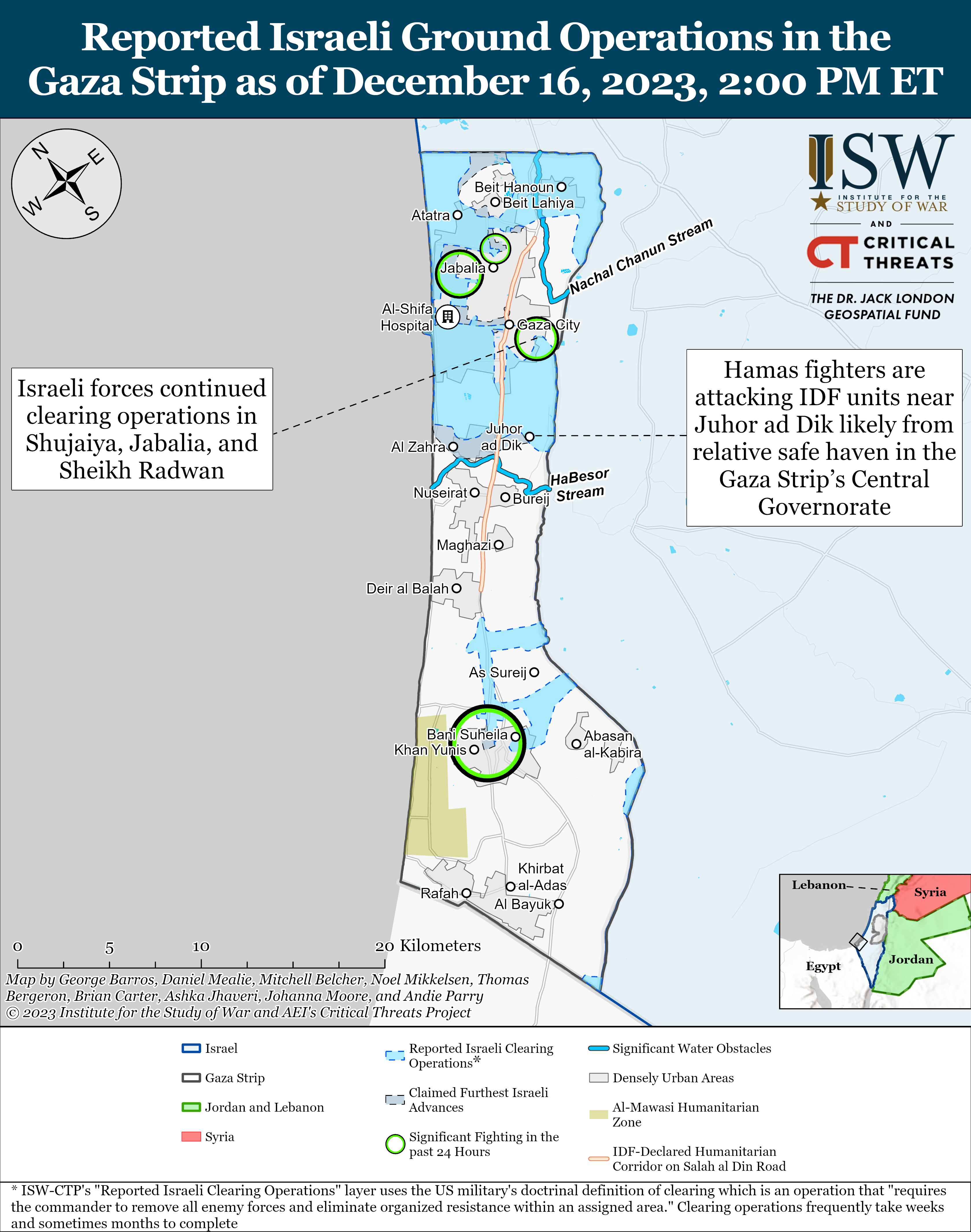
Hi, In the previous ISW/CTP update on the Israeli invasion of Gaza, a thin line showing an Israeli advance into Shujaiya was added, but on the ISW/CTP's png map, the advance is obstructed by text reading "Gaza City". I noticed that you did not update the Commons map to reflect this change. The advance has also since been further updated, while it is still largely obstructed by the text. The advance can however be seen on the ISW/CTP's interactive map. Just wanted to bring this to your attention so you can correctly update the map accordingly. Thanks, President Loki (talk) 03:14, 18 December 2023 (UTC)
Map for Operation Peace Spring
Can you add a map for Operation Peace Spring October 2019. AlAboud83 (talk) 17:26, 21 December 2023 (UTC)
2019 Turkish offensive into north-eastern Syria already appears to have an detailed map. Ecrusized (talk) 18:18, 21 December 2023 (UTC)
A map of the area between Tal Abyad and Ras Al-Ayn and detailed gains would be appreciated.AlAboud83 (talk) 05:58, 22 December 2023 (UTC)
- Here's the map. Since it does not show the broader region it might not be preferred. Ecrusized (talk) 14:50, 22 December 2023 (UTC)
you can make a separate Manbij-Kobani map and East Ras Al-Ayn to Malikiyah-Yaaroubiyah map AlAboud83 (talk) 23:06, 22 December 2023 (UTC)
Small fixes to Fitxategi:October_2023_Gaza−Israel_conflict.svg in Basque
Hi Ecrusized, I am about to upload a version with a wider textbox for the legend that fits the text, still would not like to make a mess and replace the default existing English version by means of "Upload a new version of this file". Should I upload it separately or as a version? Regards Iñaki LL (talk) 11:55, 24 December 2023 (UTC)
- @Iñaki LL: You can overwrite the file if it isn't causing any issues. Sometimes text changes can disrupt translations however. Ecrusized (talk) 12:31, 24 December 2023 (UTC)
- @Iñaki LL: I have modified to file to display the set dimensions of the legend box in Basque translation, please let me know if there are any issues. Ecrusized (talk) 19:06, 24 December 2023 (UTC)
Sderot in File:October 2023 Gaza−Israel conflict.svg
Greetings @Ecrusized, hope you are enjoying the last few days of 2023. I come to your talk page with a question regarding the lovely city of Sderot. Various iterations of the map have typically depicted the western side of Sderot as having come behind the "front line" with the eastern half untouched. I was curious to learn if there was concrete geospatial data supporting this or if it was simply divided 50-50 for purposes of estimation. I'm hoping to revamp the Wikipedia article regarding the Battle of Sderot and this will determine whether or not this file can remain on the page.
My very best wishes. SaintPaulOfTarsus (talk) 15:38, 26 December 2023 (UTC)
- @SaintPaulOfTarsus: It is just a 50:50 map. I didn't want to include all of the settlement under "Palestinian advance" to give the impression that the town was captured by the militants. The website, oct7map.com shows precisely where the attacks took place during the Hamas attack. In case you want to make a map specific to the clashes in Sderot. Ecrusized (talk) 16:26, 26 December 2023 (UTC)
Gaza map
Why you did not change the map in north Gaza Israel on its own words said I withdraw from sheikh ridhwan and many other places but still you put it under Israel control 197.0.33.124 11:13, 5 January 2024 (UTC)
A comment on copyright
Hey, Ecrusized. When you upload images to Wikimedia Commons, you have to be 100% certain that the license you upload the image with is legitimate. Despite the fact that Mehrnews claims that all of its content is under a CC BY-SA license, the images on their website are often from elsewhere. They are likely not the copyright holder of the images that you uploaded to Commons, and can therefore not apply any licenses to them. The illegitimate change of license without consent from the copyright holder is known as license laundering. Please be more careful in the future. ArcticSeeress (talk) 17:48, 9 January 2024 (UTC)
- @ArcticSeeress: As far as I know, anything from Mehr news was copyright free, based on the Template:mehr. There is no way for me to check whether a specific image is backed by this or not. You are welcome to do police work though. Ecrusized (talk) 17:53, 9 January 2024 (UTC)
- The burden of proof for permission falls on the uploader, see Commons:Project scope/Evidence: you are the one required to verify if the license is legitimate. A common way to check for yourself is to do a reverse image search through Google, Yandex, or Tineye. That is the way I found the images myself. For recent news articles like this, it is often possible to find other agencies using the images, which are more likely to list their source. If you are uncertain about the status of an image, feel free to send me (or anyone else familiar with copyright on Commons) a message. The worst that can happen is that the image isn't uploaded. ArcticSeeress (talk) 18:04, 9 January 2024 (UTC)
- Just as a heads up, I've uploaded another file from Tasnim News Agency, c:File:Wissam al-Tawil Tasnim.jpg. From what I can find, this file is covered by CC 4.0 license. Ecrusized (talk) 18:05, 9 January 2024 (UTC)
- Thanks for the heads up. According to USA Today, it is "An undated handout photo released by the Hezbollah military media press office on Telegram on Jan. 8, 2024". It is likely that the image was not released under a free license. ArcticSeeress (talk) 18:07, 9 January 2024 (UTC)
- Considering how multiple Iranian media outlets, Mehr, Raja News and Tasnim News are releasing media from Hezbollah media office, it might be releasing its own works under CC 4.0. Ecrusized (talk) 18:11, 9 January 2024 (UTC)
- Maybe, maybe not. If you can find a license agreement between the Hezbollah media office and these news agencies, then the images may be permissible on Commons. Without anything explicit, this is speculation. Emailing them would be a good start, but I don't speak Arabic or Farsi, so I can't help with this particular issue. ArcticSeeress (talk) 18:16, 9 January 2024 (UTC)
- Considering how multiple Iranian media outlets, Mehr, Raja News and Tasnim News are releasing media from Hezbollah media office, it might be releasing its own works under CC 4.0. Ecrusized (talk) 18:11, 9 January 2024 (UTC)
- Thanks for the heads up. According to USA Today, it is "An undated handout photo released by the Hezbollah military media press office on Telegram on Jan. 8, 2024". It is likely that the image was not released under a free license. ArcticSeeress (talk) 18:07, 9 January 2024 (UTC)
Map tutorial
Hey @Ecrusized, I was wondering if you could do a tutorial for creating maps as you do or maybe a video that teaches the way you do your maps Abo Yemen (talk) 12:27, 14 January 2024 (UTC)
- First you need a map base. You can get this from OpenStreetMap, by exporting portions as SVG. OpenTopoMap is also copyright free, but it doesn't have an export option afaik, so I just screen capture it. User NordNordWest also has a large gallery of maps you can use by giving him attribution. Once you have this, all you need to do is draw shapes in Inkscape, or other vector editors, such as Adobe Illustrator. You can search YouTube on how to use Inkscape. Ecrusized (talk) 12:41, 14 January 2024 (UTC)
File:Sayyed Razi Mousavi.jpg
 |
File:Sayyed Razi Mousavi.jpg has been nominated for deletion at
This is a deletion request for the community to discuss whether the nominated page should be kept or deleted. Please voice your opinion in the linked request above. Thank you very much! If you created this file, please note that the fact that it has been proposed for deletion does not necessarily mean that we do not value your kind contribution. It simply means that one person believes that there is some specific problem with it, such as a copyright issue. Please see Commons:But it's my own work! for a guide on how to address these issues. |
HeminKurdistan (talk) 18:51, 3 March 2024 (UTC)
Error in the Gaza war map
Hi, Ecrusized! I tried to use SVG Translate tool to update the Chinese translations of File:October 2023 Gaza−Israel conflict.svg. But it doesn't work, due to "This file can not be translated because it contains nested tspan elements in tspan7. " Could you please fix this error? Thanks! BlackShadowG (talk) 05:38, 12 May 2024 (UTC)
- @BlackShadowG: There was an error in the svg code of tspan7. I believe it should be fixed now. Please let me know, thanks. Ecrusized (talk) 09:27, 12 May 2024 (UTC)
- Now the tool still doesn't work, the error message is "This file contains a switch element that contains an element that is not a text element.". BlackShadowG (talk) 09:54, 12 May 2024 (UTC)
- @BlackShadowG: I'm not sure really. Also, the svg translate tool will probably fail to overwrite the file due to it being fully protected at the moment. However, if you give me the Chinese translation, I could update it manually. Ecrusized (talk) 11:21, 12 May 2024 (UTC)
- Now the tool still doesn't work, the error message is "This file contains a switch element that contains an element that is not a text element.". BlackShadowG (talk) 09:54, 12 May 2024 (UTC)
Lebanon War 2006
Can you create a map for the 2006 Lebanon War, in particular the Israeli ground operation at that time. AlAboud83 (talk) 21:06, 9 June 2024 (UTC)
- I would need reliable sources showing the Israeli ground movements during that war. Ecrusized (talk) 21:31, 9 June 2024 (UTC)
The Wikipedia article about the war and in particular the page on operation change of direction 11 is rich with information about the ground war during that war. AlAboud83 (talk) 22:18, 9 June 2024 (UTC)
File:Flag of Popular Mobilization Forces.svg
|
File:Flag of Popular Mobilization Forces.svg has been nominated for deletion at
This is a deletion request for the community to discuss whether the nominated page should be kept or deleted. Please voice your opinion in the linked request above. Thank you very much! If you created this file, please note that the fact that it has been proposed for deletion does not necessarily mean that we do not value your kind contribution. It simply means that one person believes that there is some specific problem with it, such as a copyright issue. Please see Commons:But it's my own work! for a guide on how to address these issues. |
Thespoondragon (talk) 05:58, 10 July 2024 (UTC)
File:Somali Civil War 22 May 2024.svg
|
File:Somali Civil War 22 May 2024.svg has been nominated for deletion at
This is a deletion request for the community to discuss whether the nominated page should be kept or deleted. Please voice your opinion in the linked request above. Thank you very much! If you created this file, please note that the fact that it has been proposed for deletion does not necessarily mean that we do not value your kind contribution. It simply means that one person believes that there is some specific problem with it, such as a copyright issue. Please see Commons:But it's my own work! for a guide on how to address these issues. |
WeaponizingArchitecture (talk) 15:23, 4 August 2024 (UTC)
Reverting against consensus
Hi. Please respect the community consensus. I've explained on the talk page why we have one.
At the risk of making a "threat" and sounding nasty when I'd rather play nice, if you against restore your version, I will appeal for administrators intervention. (I am an administrator but will not do so since I took part in the discussion). Magog the Ogre (talk) (contribs) 22:24, 13 August 2024 (UTC)
Request for a map update
Hey Ecrusized! So I saw you made File:Military Occupations.svg. Funny enough, it actually needs updating, despite being made earlier this year. The w:Ukrainian occupation of Kursk Oblast has already been added to the w:List of military occupations, where the map is in use. Is there a chance you could update the map with it? WeatherWriter (talk) 15:29, 17 August 2024 (UTC)
File talk:August 2024 Kursk Oblast incursion.svg
Hello. It was very improvident to create a map File talk:August 2024 Kursk Oblast incursion.svg with such a small area of coverage. A wider map is needed, covering the territory of at least several districts of the Kursk region, maybe up to the city of Kursk, whose future is in question. I think the author of the map should correct his own shortcoming. Blast furnace chip worker (talk) 13:16, 18 August 2024 (UTC)
Syrian Civil War Map edit request
Hello Ecrusized! I have noticed that your Syrian Civil War map colours the Golan Heights/Quneitra as the rest of the world. I feel like this is a bit misleading, and that it would be better if you could kindly add something like a stripped colour over the Quneitra region or use a different colour over the Quneitra region to show its relation with Syria, considering almost all countries in the world internationally recognises Golan/Quneitra as a part of Syria. It can be labelled as "Israeli-occupied territory claimed by Syria" or "Israeli-occupied territory internationally recognised as a part of Syria." This would explain the reason behind the striped border between Israel and Syria and give some context to individuals who are unaware. Plus, it looks odd, as if Quneitra is its own country, given the current map, so colouring it over would make sense. Would be very nice if you would do it.
PS. I tried to work on your map (which I did) and publish it giving you credits and under the same license, but Wikipedia kept giving me errors and I could not figure out what to do. So I am requesting you whether you could make this change. Thanks. GucciNuzayer (talk) 16:48, 12 September 2024 (UTC)
- I think Golan Heights is best represented in the map in its current form. Adding dashed lines or other marks asserting Israeli control may mislead the reader to believe its status has changed during the Syrian civil war. The border between Golan Heights and Syria are marked with dashed lines so it will be indicated that this is not an international boundary. Ecrusized (talk) 11:18, 16 September 2024 (UTC)
File:Military Occupations.svg
The map contains a serious mistake: the names of Armenia and Azerbaijan are mixed up. --Dmitri Lytov (talk) 13:18, 24 September 2024 (UTC)
Corrections of CA and added translations for ES and FR
I tried to upload it myself, but it was blocked. So could you please do it? Thank you. The file can be found here: https://cryptpad.fr/file/#/2/file/i6xpVN7kXxhFaMHc3y4Y6IYa/ Erik del Toro Streb (talk) 07:21, 3 October 2024 (UTC)
Israel progression in Lebanon
Here are some sources of maps of the IDF advancements into Lebanon that I would like you to consider:
https://www.understandingwar.org/backgrounder/iran-update-october-12-2024
Prodrummer619 (talk) 11:06, 13 October 2024 (UTC)
- I'm only using ISW, liveuamap and ISW are unreliable sources. Ecrusized (talk) 11:20, 13 October 2024 (UTC)
- Please note that Hezbollah yesterday announced that the Israeli occupation have not yet took control of any village in Lebanon. 94.129.71.110 08:59, 24 October 2024 (UTC)
Northwestern Syria offensive (2024), Aleppo.svg
Hi, I checked the map File:Northwestern Syria offensive (2024), Aleppo.svg and wanted to note that en:Sheikh Maqsood in North Aleppo city is under SDF control. Semsûrî (talk) 10:39, 30 November 2024 (UTC)
,_Aleppo.svg)
A barnstar for you!
 |
The Graphic Designer's Barnstar |
| For the maps that you make Abo Yemen✉ 16:44, 1 December 2024 (UTC) |
Map
Hello, could you ad that Israel occupies the Golan Heights to this map? https://commons.wikimedia.org/wiki/File:Northwestern_Aleppo_offensive_(2024).svg 2001:9B1:106:0:0:0:E97D:6553 02:37, 3 December 2024 (UTC)
.svg)
Update the Aleppo map
the SDF has withdrawn from Aleppo https://thecradle.co/articles-id/27925 Berniesandals (talk) 16:09, 3 December 2024 (UTC)
- There hasn't been a final deal reached yet. Ecrusized (talk) 16:12, 3 December 2024 (UTC)
- Map for Aleppo+Hama should not be the other for full Syria. Panam2014 (talk) 16:26, 3 December 2024 (UTC)
,_(Syria).svg)
File:August 2024 Kursk Oblast incursion.svg requires updating
Hi Ecrusized,
Thank you for your contributions to Commons. I noticed File:August 2024 Kursk Oblast incursion.svg is out of date. Could you update it? Thanks again. Firestar464 (talk) 22:52, 3 December 2024 (UTC)
Syria Map
Thanks for your updates on the Syrian war maps, but file:Northwestern Syria offensive (2024).jpg needs a correction. in south east, thats not under control neither by the HTS & SNA, thats under control by US forces and its allies (Revolutionary Commando Army). see this map File:Syrian Civil War map.svg as an correct example regarding the south east part. the south part of your new map is correct though, while that part of the Syrian Civil War map is outdated (its not anymore a stable truce area). best regards and keep up the good work :) LennBr (talk) 00:01, 7 December 2024 (UTC)
.jpg)
- Furthermore, I believe in the initial days of the offensive, the SDF attempted to encircle Aleppo from the east but was cut of by Turkish backed SNA and forced to withdraw. Since the map includes advances, perhaps it should include the SDF offensive towards Aleppo in the beginning. Yxuibs (talk) 00:40, 8 December 2024 (UTC)
- Hi, sorry for not replying earlier. I cannot separate the areas under HTS, SNA and SFA control at the moment because its not clear where each of them have captured. Regarding SDF, I could separate the areas rebels have captured from pro-government forces and SDF but for the time being I prefer keeping it combined. Mostly, SDF has handed over the areas it had captured in Aleppo region after government forces left to the rebels without fighting in just a few days. So it doesn't need a strong emphasis. If Turkey and the SNA launch an offensive on the SDF, I will be making a difference between the two. Ecrusized (talk) 00:45, 8 December 2024 (UTC)
Please do not edit war
--Yann (talk) 16:30, 9 December 2024 (UTC)
- Based on the fact you've been warned elsewhere not to edit war, you're well aware of the procedures. I've blocked your account for three days. Magog the Ogre (talk) (contribs) 01:09, 10 December 2024 (UTC)
- @Magog the Ogre: No further reverts had taken place after the warning by Yann. Another user reverted after that, which I overwrote in the version they have reverted to upgrade the file. Ecrusized (talk) 10:10, 10 December 2024 (UTC)
- Yann was likely unaware that you've been previously warned, or else he would have blocked you outright (as I did). You made four reverts on that page while no one else made more than one. And "another user reverted me afterward" is not a valid defense for edit warring. Magog the Ogre (talk) (contribs) 01:00, 13 December 2024 (UTC)
- @Magog the Ogre: No further reverts had taken place after the warning by Yann. Another user reverted after that, which I overwrote in the version they have reverted to upgrade the file. Ecrusized (talk) 10:10, 10 December 2024 (UTC)
Map at 2024 Israeli invasion of Syria
On December 11th a reporter from Kan 11 was embedded with IDF at Tel al-Kudnah, about 32.997121, 35.884719. See video hereː https://x.com/ItayBlumental/status/1866882659823038579. GordonGlottal (talk) 21:07, 15 December 2024 (UTC)
- See also report here from Channel 12, IDF has occupied Tel Kudnah. https://www.mako.co.il/news-military/036814c74a0e1910/Article-b763205d006b391027.htm GordonGlottal (talk) 20:07, 17 December 2024 (UTC)
Syrian transitional government map
- Hello, Ecrusized. The maps at "File:Syrian Civil War map.svg" as well as at "File:Syrian Civil War map (ISW-CTP).svg" are heavily outdated and incorrect. Can you upload a Syrian transitional government map which demarcates four factions?
- i) Syrian transitional government (HTS, Southern Operations Room and allies)
- ii) SFA & US occupation
- iii) SNA & Turkish occupation
- iv) SDF & US occupation
- You can read the discussion at talk page
- Shadowwarrior8 (talk) 02:00, 5 January 2025 (UTC)
- I've tried updating the first file you mentioned but I was reverted every time I tried to. You can overwrite it with this one if you prefer File:Syrian civil war (January 2025).svg. The second file you mentioned seems to be accurately cited with its citation. Ecrusized (talk) 12:36, 5 January 2025 (UTC)
- Hello, Ecrusized.
- The issue with the file "File:Syrian Civil War map (ISW-CTP).svg" is that its source is the "Institute for the Study of War", which is an American right-wing military think-tank which collaborates with the "American Enterprise Institite". The "American Enterprise Institute", which releases the "Critical threats" maps, is literally a neo-con think-tank[1] which is also rabidly pro-Nentanyahu.[2] Since it is an extremely biased American and pro-Israeli neo-con propaganda source, my view is that ISW should not be used in mapping at all. Shadowwarrior8 (talk) 08:19, 1 February 2025 (UTC) Shadowwarrior8 (talk) 08:19, 3 February 2025 (UTC)
- I've tried updating the first file you mentioned but I was reverted every time I tried to. You can overwrite it with this one if you prefer File:Syrian civil war (January 2025).svg. The second file you mentioned seems to be accurately cited with its citation. Ecrusized (talk) 12:36, 5 January 2025 (UTC)
.svg)
References
- ↑ Schifferes, Steve (April 3, 2003). "Battle of the Washington think tanks". BBC News. Archived from the original on January 6, 2009. Retrieved February 12, 2009.
- ↑ Israeli Prime Minister Benjamin Netanyahu to receive 2015 AEI Irving Kristol Award. aei.org. Archived from the original on January 13, 2023. Retrieved on January 13, 2023.
Map over at Israeli invasion of syria
Hey man sorry to bother you. I noticed that the map you created over at the Israeli invasion of syria page is a bit outdated. If there are any changes at Liveuamap would you mind updating the map? I would do it myself but it seems complicated as fuck. Thanks :) DeadlyRampage26 (talk) 09:22, 12 January 2025 (UTC)
Software Used?
Hi Ecrusized! I was wondering how you what software you were using to produce your maps. It would be great for personal use and possible other Wikipedia articles in the future. Thanks! LunarEcho87 (talk) 02:16, 21 January 2025 (UTC)
New, clearer and updated transitional government map
Hello, Ecrusized.
I think the main problem with the current version of the Syrian transitional government (STG) map is that it includes US-occupied region in al-Tanf and Turkish-occupied region in northern Syria as part of the territories controlled by the Syrian transitional government (STG).
.svg)
The Southern Operations Room (SOR) was a front established in co-ordination with the Military Operations Command (MOC) and was already allegiant to STG since December of 2024. (sources ) ISW-CTP map's differentiation between Syrian transitional government and SOR was false and disinformation from the very outset.
Following the recent dissolution of armed revolutionary factions, (source: ) SOR has also operationally merged into the new Syrian Armed Forces. (Sources: )
Regarding the Syrian National Army, it has expressed its support to the Syrian transitional government. (source: ) The position of Turkey is also to disband SNA and hand over its weapons to the Syrian Armed Forces. (sources: , ) Some factions of the SNA also participated in the "Syrian revolution victory conference" and agreed to disband. However, as of 3 February 2025, SNA has de-facto control over regions in northern Syria.
SFA has renounced control of Palmyra to STG, hence there is no reason to mark them in the map.
Hence, my proposal is to create a map in this format:
i) Syrian transitional government (white) - territories controlled by the Syrian Armed Forces, the currently pink-marked territories (in the ISW-CTP map) of Southern Operations Room, which is now a wing of the Syrian Armed Forces, and the grey-marked territories (in the ISW-CTP map) which are all de-facto ruled by the Syrian transitional government.
ii) Syrian National Army and Turkish occupation (green)
iii) US occupation in al-Tanf (light green)
iv) SDF and US occupation (yellow) Shadowwarrior8 (talk) 09:55, 3 February 2025 (UTC)
Syria
Hi
Could you made maps for Southern Syria Offensive (Deraa/Suweyda/Qusayr) ? And for Aleppo, Hama and Homs and Damascus? You could also do a gif animated version. Panam2014 (talk) 02:39, 9 February 2025 (UTC)
"Crimea is internationally recognized as Ukrainian territory"
"Crimea is internationally recognized as Ukrainian territory" — to present evidence of the withdrawal of Israeli troops from the Golan Heights, which are "internationally recognized" as the territory of Syria. Or is it "different" for you, right, Jew? 176.15.242.203 10:10, 15 February 2025 (UTC)
October 2023 Gaza−Israel conflict map
Hi Ecrusized. I just thought I would leave a wee note to tell you, what a fantastic map you have created. Excellent detail. Trully excellent. Scope creep (talk) 12:31, 17 February 2025 (UTC)
Syrian civil war (ISW-CTP)
Hello, @Ecrusized, hope you're doing all well, can you please update the Syrian civil war map to reflect STG gains in Azaz, Jarbulus and Suweida M Waleed (talk) 05:02, 21 February 2025 (UTC)
- You don't need to message me everyday for an update. I check it on a regular basis. Also, I will not update the other variant full of green shades. I don't like it as I already stated. Please do not message me to update that file. Ecrusized (talk) 09:36, 22 February 2025 (UTC)
- Sorry man if I had been annoying, I'd not disturb or unnecessarily ping ya from now on, I promise M Waleed (talk) 15:18, 22 February 2025 (UTC)
- @Ecrusized, it's been two days since I requested an update on the Daraa Suweida border but it hasn't been updated so I was wondering, can you please? M Waleed (talk) 04:06, 13 March 2025 (UTC)
- Updated. Ecrusized (talk) 10:06, 13 March 2025 (UTC)
Gaza map
Hello, As you may know, ISW-CTP's daily "Iran Update" no longer includes data regarding the Gaza War. Will you continue to update the map from other sources instead? President Loki (talk) 08:46, 23 March 2025 (UTC)
- I think ISW will release an update soon. I'll update it when they do. Ecrusized (talk) 15:25, 23 March 2025 (UTC)
- It looks like ISW-CTP has still not issued an update, so I'm wondering if you will continue updating the map from alternate sources. President Loki (talk) 22:26, 4 April 2025 (UTC)
- @President Loki: I'm not aware of any other reliable sources providing data on where Israel currently operates in Gaza Strip. If you know any you can post them here. Although I can only use them if they are reliable sources. Ecrusized (talk) 13:37, 6 April 2025 (UTC)
- I don't know if you would consider this a reliable source, but there is an Israeli geo-analyst who regularly posts detailed and informative, mainly geographical, updates regarding the Gaza War named Ben Tzion Macales.
- From time to time he posts an up to date map of the Gaza War.
- Here is the most recent update, from 18 May. President Loki (talk) 21:23, 19 May 2025 (UTC)
- It could be used I suppose. Although it might create w:WP:SYNTH issues because the maximum advance and current presence will be citing separate sources. Ecrusized (talk) 17:38, 20 May 2025 (UTC)
- @Ecrusized Regarding the evacuation zones on the map, I suggest updating them as they are currently outdated. Perhaps use this article, which contains a map of all current evacuation zones. (paywall free version)
- Also, there was a new map update today from Ben Tzion Macales. President Loki (talk) 17:38, 4 June 2025 (UTC)
- It could be used I suppose. Although it might create w:WP:SYNTH issues because the maximum advance and current presence will be citing separate sources. Ecrusized (talk) 17:38, 20 May 2025 (UTC)
- @President Loki: I'm not aware of any other reliable sources providing data on where Israel currently operates in Gaza Strip. If you know any you can post them here. Although I can only use them if they are reliable sources. Ecrusized (talk) 13:37, 6 April 2025 (UTC)
- It looks like ISW-CTP has still not issued an update, so I'm wondering if you will continue updating the map from alternate sources. President Loki (talk) 22:26, 4 April 2025 (UTC)
Data for Myanmar civil war map
I see you are the author of this excellent map: https://commons.wikimedia.org/wiki/File:Myanmar_civil_war.svg I am a volunteer with charity MapAction being deployed to Myanmar to help with the humanitarian response to the earthquake. Do you have any underlying geospatial datasets for this map? Or was it all drawn in Inkscape? If you do have the data, please could you provide it? Thank you. Harry Kuril (talk) 11:52, 2 April 2025 (UTC)
- @Harry Kuril: Hello, this file is an edited version of the file w:File:Myanmar adm location map.svg by user NordNordWest. It's not an original work of mine. Best regards. Ecrusized (talk) 12:12, 2 April 2025 (UTC)
- Thank you for your reply. The map you link by @NordNordWest appears to be a simple blank country template. The part I'm interested in is the coloured blobs showing factional control. Did you create the blobs? Harry Kuril (talk) 13:41, 2 April 2025 (UTC)
- @Harry Kuril: Factional control is citing the work of @Thomas van Linge. I did create the first blobs in 2023 based on his work, but since then these have been modified by many editors as the frontlines changed. Ecrusized (talk) 14:22, 2 April 2025 (UTC)
- Thank you. Harry Kuril (talk) 17:52, 21 April 2025 (UTC)
- @Harry Kuril: Factional control is citing the work of @Thomas van Linge. I did create the first blobs in 2023 based on his work, but since then these have been modified by many editors as the frontlines changed. Ecrusized (talk) 14:22, 2 April 2025 (UTC)
- Thank you for your reply. The map you link by @NordNordWest appears to be a simple blank country template. The part I'm interested in is the coloured blobs showing factional control. Did you create the blobs? Harry Kuril (talk) 13:41, 2 April 2025 (UTC)
Gaza map (Popular Forces)
Just wanted to let you know, the pocket in Al-Bayuk on the Gaza map is actually currently controlled by the Gaza-based Israeli-backed Popular Forces, hence why it is given it's own color on the source map. Perhaps it would make sense to add a third color to the map to reflect this control? President Loki (talk) 10:07, 1 July 2025 (UTC)
- Thanks, I was wondering what that meant but I couldn't tell because the map is in Hebrew. Although I'm not supportive of the idea of adding another color to the legend because it would break other language translations. I suppose current form is fine since the map only separates Israel and Palestinian controlled territory, without showing a distinction between Hamas and Popular Forces. Ecrusized (talk) 20:06, 1 July 2025 (UTC)
Evacuation zones
Just wanted to let you know, the IDF has posted an official interactive map of all evacuation zones here.
Also I might as well mention there's been a couple more updates from Ben Tzion Macales recently. President Loki (talk) 15:45, 20 July 2025 (UTC)
- Updated, thanks for sharing the source. Ecrusized (talk) 19:40, 20 July 2025 (UTC)
- @Ecrusized just letting you know, there was another update today as well President Loki (talk) 16:37, 21 July 2025 (UTC)
Small Mistakes on File:Syrian Civil War map (ISW-CTP).svg
Hello, I have been following the Syrian Civil War for quite some time, and I have noticed a few of (what I assume to be) mistakes on the map.
First off, the tri-point of the Quneitra, Rif Damashq and Daraa Governorates (near Kawm al Wibsah) is controlled by the IDF despite no source confirming this. I assume this is a mistake because it looks like a regular border without close inspection.
Secondly, the town of Abar al-Mawahib (to the east of Palmyra) is still controlled by Assad. This also is highly dubious.
I also discovered four cities in grey near Homs. They are as follows: 2 Air Defense Sites, 1 Air Defense Academy and the town of Jandar (East of al-Qusayr).
And finally, a recent update led to the color of many cities in Suwayda Governorate to not accurately align with the territory around them. This is mainly in the north of the governorate.
I know it may not seem like big deals individually, but I feel it casts a poor image on us to allow so many small mistakes. Zappycat1234 (talk) 20:46, 18 September 2025 (UTC)
Gaza Map update
Apparently, there are many developments occurring in Gaza City. AlAboud83 (talk) 19:38, 26 September 2025 (UTC)
CIS map update request
Hello, Ecrusized.
In File:CIS (members, associaton members, observers, former members and disputed territories) - 2024.png, can you remove Artsakh (Nagorno-Karabakh) inside Azerbaijan, because it ceased to exist after Azerbaijan retook it in 2003?
_-_2024.png)
Yours sincerely, 2A00:1D36:1011:5701:62A4:EB1A:2085:A018 21:01, 16 October 2025 (UTC)
- Done. Ecrusized (talk) 21:32, 16 October 2025 (UTC)
- Thank you very much. 2A00:1D36:1011:5701:D06F:51A:8081:4794 06:42, 17 October 2025 (UTC)
EU map update request
Hello, Ecrusized.
Can you remove the United Kingdom in File:European Union as a single entity.png? It ceased to be a member of the European Union with Brexit in 2020.
Yours sincerely, 2A00:1D36:1011:5701:62A4:EB1A:2085:A018 21:05, 16 October 2025 (UTC)
- Can you also update this map, because it is a current-day map which is used in Wikipedia articles as such? 2A00:1D36:1011:5701:D06F:51A:8081:4794 06:44, 17 October 2025 (UTC)
- Done. Ecrusized (talk) 11:11, 17 October 2025 (UTC)
- Thank you very much. 2A00:1D36:1011:5701:E954:13D8:A98C:6606 13:23, 17 October 2025 (UTC)
- Done. Ecrusized (talk) 11:11, 17 October 2025 (UTC)
Allow overwriting
I updated latest protests by cities in the file File:2025_Iranian_protests_map.svg and requested it on Commons:Overwriting existing files/Requests. So would you please give a hand?
Thanks in advance UnrivaledIr (talk) 11:13, 1 January 2026 (UTC)
Syrian conflict map Need update
Update on the map: The Syrian army has entered the town of Al-Shaab in eastern Sweida in the Syrian desert. Source Mouaz01 (talk) 13:26, 1 January 2026 (UTC)
Yemen civil war map need update
The Yemeni government now controls eastern provinces ~2026-53448 (talk) 18:37, 3 January 2026 (UTC)
File:Nicolas Maduro on board the USS Iwo Jima.png
|
File:Nicolas Maduro on board the USS Iwo Jima.png has been nominated for deletion at
This is a deletion request for the community to discuss whether the nominated page should be kept or deleted. Please voice your opinion in the linked request above. Thank you very much! If you created this file, please note that the fact that it has been proposed for deletion does not necessarily mean that we do not value your kind contribution. It simply means that one person believes that there is some specific problem with it, such as a copyright issue. Please see Commons:But it's my own work! for a guide on how to address these issues. |
Yemen newer update
@Ecrusized, Newer update: The UAE-backed Giants Brigades militia has taken control of strategic locations in Aden after the withdrawal of STC forces from checkpoints in the city. [aljazeera]. It has since taken over the STC Headquarters, the central bank, several other government buildings, and the presidential palance. Likely anticipating the Homeland Shield forces (قوات درع الوطن) of Yemen. Kaliper1 (talk) 15:51, 7 January 2026 (UTC)
- Its a rapidly moving situation, I will update the map as soon as there are reports about where the current boundary between STC and Yemeni Gov forces are. Thanks for the information. Ecrusized (talk) 15:55, 7 January 2026 (UTC)
- Glad to monitor. If I had the opportunity, I would be open to edit myself as I did for Syria; however, I am without the needed permissions to do so. Leaving little options at the moment. Good luck for the map making. Cheers, Kaliper1 (talk) 16:03, 7 January 2026 (UTC)
- I requested auto patrol protection on this file to prevent edit warring, you can request auto patrol rights on commons if you're an experienced editor, I think you can get this right easily. Ecrusized (talk) 16:10, 7 January 2026 (UTC)
- I think Yemen captured Aden (Governorate). It’s on the current events board. ~2026-17294-1 (talk) 03:38, 9 January 2026 (UTC)
- Also, I find it hard to believe that Yemen just skips Lahij Governorate and wastes the opportunity to take it and also flank the Houthis more easily. ~2026-17294-1 (talk) 04:15, 9 January 2026 (UTC)
- @~2026-17294-1 Is this a "you think" or is there a source to this? and no a forum does not count as a source. Maybe the sources cited in the forums could be used if you have those. Kaliper1 (talk) 04:27, 9 January 2026 (UTC)
- https://www.middleeasteye.net/news/yemen-stc-control-evaporates-aden-its-would-be-capital-switches-sides
- https://www.aa.com.tr/en/middle-east/yemen-government-forces-move-into-aden-as-power-balance-shifts-in-south/3793442
- https://www.yahoo.com/news/videos/saudi-backed-forces-begin-deploying-003816425.html (AP) ~2026-17294-1 (talk) 06:46, 9 January 2026 (UTC)
- @~2026-17294-1 I've read the citations you gave. The articles state Aden as the city. Not the governate. Ecrusizeds' edit has already refected this. Kaliper1 (talk) 08:23, 9 January 2026 (UTC)
- I know, but I've seen some reports that state the PLC captured all districts of Aden Governorate, so I just put it in parentheses.It doesn't really matter now, but still. ~2026-14298-6 (talk) 15:08, 9 January 2026 (UTC)
- @~2026-17294-1 I've read the citations you gave. The articles state Aden as the city. Not the governate. Ecrusizeds' edit has already refected this. Kaliper1 (talk) 08:23, 9 January 2026 (UTC)
- @~2026-17294-1 Is this a "you think" or is there a source to this? and no a forum does not count as a source. Maybe the sources cited in the forums could be used if you have those. Kaliper1 (talk) 04:27, 9 January 2026 (UTC)
- Also, I find it hard to believe that Yemen just skips Lahij Governorate and wastes the opportunity to take it and also flank the Houthis more easily. ~2026-17294-1 (talk) 04:15, 9 January 2026 (UTC)
- I think Yemen captured Aden (Governorate). It’s on the current events board. ~2026-17294-1 (talk) 03:38, 9 January 2026 (UTC)
- I requested auto patrol protection on this file to prevent edit warring, you can request auto patrol rights on commons if you're an experienced editor, I think you can get this right easily. Ecrusized (talk) 16:10, 7 January 2026 (UTC)
- Glad to monitor. If I had the opportunity, I would be open to edit myself as I did for Syria; however, I am without the needed permissions to do so. Leaving little options at the moment. Good luck for the map making. Cheers, Kaliper1 (talk) 16:03, 7 January 2026 (UTC)
Another Yemen update (if you don't mind!)
Hello Ecrusized! I hope you're well, and thank you for your continued work in keeping up some of the most important military maps of Wikimedia 🙂 Out of sheer curiosity, I was updating the article for w:Zuqar Island, and per this source by the ISPI, "Regarding the Emirati-backed groups, Tareq Saleh's National Resistance Forces, a coalition which oppose the Houthis while not formally part of the regular security sector, are stationed at Zuqar (Southern Red Sea) and Perim/Mayyun (Bab el-Mandeb)." I believe Zuqar Island, alongside the rest of the w:Hanish Islands + w:Perim should be marked as under National Resistance Forces control (blue) and not government control (red). These islands already have very little if not no population outside of military, so not much news comes from them, which is probably why they've been marked red for so long. Literally no rush, and thank you for all the work you do in mapping. Cheers from North Carolina! Johnson524 (talk) 02:11, 11 January 2026 (UTC)
ISW Updated
Hello @Ecrusized, I just want to tell info that ISW has updated its recent maps, post ceasefire deal. The map SVG is also updated now. Cheers, Kaliper1 (talk) 05:38, 19 January 2026 (UTC)
Question
https://commons.wikimedia.org/wiki/File:Syrian_Civil_War_map.svg
https://commons.wikimedia.org/wiki/File:Claimed_and_de_facto_territory_of_Rojava.png
should scw map go to rojava?! Loptač01 (talk) 05:17, 21 January 2026 (UTC)
Your version has incorrect borders.
Why are you not addressing the incorrect governorate borders, then switch topics by saying Reverting unsourced changes by Freedoxm back to latest ISW version: https://understandingwar.org/research/middle-east/iran-update-january-21-2026
? 🗽Freedoxm🗽 (talk) 19:57, 22 January 2026 (UTC)
- @Freedoxm: Why are you leaving me a message on my talk page instead of answering to your ping on that files talk page? File talk:Syrian Civil War map.svg#Unsourced changes. Ecrusized (talk) 19:59, 22 January 2026 (UTC)
Israeli invasion of Syria
Hello. Could you please consider updating the map for the Israeli invasion of Syria, using the following map as reference, if you get the chance? https://karamshaar.com/syria-in-figures/israels-buffer-zone-in-syria-incursions-bases-impact/ I would do it but know nothing of map making or editing. Thank you UncleBourbon (talk) 06:38, 11 February 2026 (UTC)
- This map is incorrect, its probably citing https://syria.liveuamap.com/ which is almost entirely original research. The correct occupation boundary is shown by ISW which is what the map currently cites. https://storymaps.arcgis.com/stories/1933cb1d315f4db3a4f4dcc5ef40753a Ecrusized (talk) 08:28, 11 February 2026 (UTC)
- Fair enough. However, doesn't the ISW map depict Israeli territorial control extending all the way to Ain al-Nuriyah and UNDOF Camp Faouar, whereas your current map does not? Same with the areas both north and south of the Mantara Dam, northeast of Rwihinah, on the eastern shore of Lake Al Ghadir. Could you please consider updating these areas in-line with the ISW map, if you get the chance? UncleBourbon (talk) 14:56, 11 February 2026 (UTC)
- There appear to have been some changes around Quneitra and Khan Arnabah since the last updated, I've updated File:2024 Israeli invasion of Syria.png based on ISW. Ecrusized (talk) 09:42, 12 February 2026 (UTC)
- Thank you very much! UncleBourbon (talk) 10:09, 12 February 2026 (UTC)
- There appear to have been some changes around Quneitra and Khan Arnabah since the last updated, I've updated File:2024 Israeli invasion of Syria.png based on ISW. Ecrusized (talk) 09:42, 12 February 2026 (UTC)
- Fair enough. However, doesn't the ISW map depict Israeli territorial control extending all the way to Ain al-Nuriyah and UNDOF Camp Faouar, whereas your current map does not? Same with the areas both north and south of the Mantara Dam, northeast of Rwihinah, on the eastern shore of Lake Al Ghadir. Could you please consider updating these areas in-line with the ISW map, if you get the chance? UncleBourbon (talk) 14:56, 11 February 2026 (UTC)
Russo-Ukr conflict maps
Hi @Ecrusized, I have a request for you. And frankly that will take some time to complete. I see that you have been working with Inkscape and have worked for this and many other conflicts. Some highly used maps related to the Russo-Ukr conflict needs frontline update. It would be great if you would it. The (two) users who used to update them previously have been inactive for some time now. The maps are–
- File:2022 Russian invasion of Ukraine.svg (last frontline update in Dec 2025)
- File:Russian Occupation of Donetsk Oblast.svg (movements near Myrnohrad, Pokrovsk, Siversk, Kostiantynivka, Lyman)
- File:Russian Occupation of Kharkiv Oblast.svg (north eastern part)
- File:Huliaipole front of the Russo-Ukrainian war.svg (most of the town and surroundings captured)
- File:Russian Occupation of Zaporizhzhia Oblast No Background.svg (Huliaipole)
- File:Russian Occupation of Zaporizhzhia Oblast.svg (minor updates)
You already know that the map by Institute for the Study of War is used as reference. Shaan SenguptaTalk 13:04, 1 March 2026 (UTC)
Israeli-occupied Territory in Syria and ISW
The ISW map is very outdated and doesn't reflect the current situation, I recommend the map done by @Stinky915846091, which is reflected in this map https://commons.wikimedia.org/wiki/File:2026_Lebanon_War_Map_(February-Present).svg. AlAboud83 (talk) 18:17, 6 April 2026 (UTC)
.svg)