History maps
This section holds a short summary of the history of the area of present-day Austria, illustrated with maps, including historical maps of former countries and empires that included present-day Austria.
 |
Possible extent of (proto-)Celtic influence 800-400 BC
Die Kelten in Europa. Ocker: Kernbereich Nordwestalpine Hallstattkultur (ca. 750–500/450 v. Chr.) grün: Ausbreitung La-Tène-Kultur, bzw. orange: der keltischen Sprache (3. Jh. v. Chr.) |
 |
Celts in Europe
Die Kelten in Europa |
 |
Map showing the pre-Migration Age distribution of the Germanic tribes in Proto-Germanic times, and stages of their expansion up to 50 BC, AD 100 and AD 300. The extent of the Roman Empire in 68 BC and AD 117 is also shown.
Proto-Germanische Völker |
 |
Territorial development of the Roman Empire 264 BC-192,
Territoriale Entwicklung des Römischen Reiches, inklusive die Eroberung des hießigen Österreichs |
 |
Map of the Roman Empire, 50 BC
Das Römische Reich im Jahre 50 v. Chr. |
The extent of the Roman Republic and Roman Empire;
44 BC (late Republic, after conquests by republican generals)
AD 14 (death of Augustus)
117 (maximum extension
Die territoriale Entwicklung der Römische Republik und des Römischen Reiches. )
|}
 |
Camps of the Roman Legions, AD 80
Römische Legionen im Jahre 80 |
 |
Map of the Roman Empire, AD 116
Das Römische Reich im Jahre 116 |
 |
The Roman Empire and Germania, AD 116
Das Römische Reich und Germanien im Jahre 116 |
 |
Raetia in the Roman Empire, AD 116
Raetia im Römischen Reich (116) |
 |
The Roman Provinces in present-day Austria |
 |
Rhaetian and Upper Germanic Limes
Rhätien und Obergermanien mit Limes |
The division of the Empire after the death of Theodosius I, ca. 395 AD superimposed on modern borders.
Die Teilung des Römischen Reiches rund dem jahre 395.
|}
 |
Invasions of the Roman Empire 100-500 |
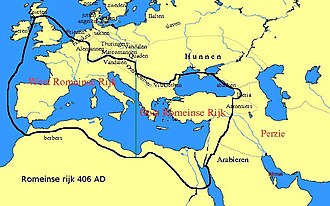 |
Division of the Roman Empire in 406 |
 |
The Franconian Empire |
 |
Carolingian Empire (in French) |
 |
Europe in 814
Europa im Jahre 814 |
 |
Division of the Frankish Empire after 870 |
 |
Central Europe 919-1125 |
 |
The Duchy of Bavaria in the 10th century |
 |
The area ruled by Ottokar II, between 1253 and 1271 |
 |
The Holy Roman Empire in the 14th century |
 |
The Holy Roman Empire and its circles in 1512 |
 |
The same map in German. |
The (Habsburg) Empire of Charles I/V.
|}
 |
The (Habsburg) Empire of Charles I/V |
 |
Religious situation in central Europe about 1618 |
 |
Area controlled by the Holy Roman Empire around 1630 |
 |
German Confederation |
 |
Borders of the German Confederation in 1820 |
 |
Aftermath of the Austro-Prussian War (1866). |
 |
French map of Austria-Hungary 1887. Pink : Cisleithania. Yellow : Transleithania. Orange : Ottoman Bosnia under austrian-hungarian occupation |
 |
Kingdoms and countries of Austria–Hungary:
Cisleithania: 1. Bohemia, 2. Bukovina, 3. Carinthia, 4. Carniola, 5. Dalmatia, 6. Galicia, 7. Austrian Littoral, 8. Lower Austria, 9. Moravia, 10. Salzburg, 11. Silesia, 12. Styria, 13. Tyrol, 14. Upper Austria, 15. Vorarlberg;
Transleithania: 16. Hungary, 17. Croatia and Slavonia;
18. Bosnia and Herzegovina |
 |
Religions in Austria-Hungary, Andrees Allgemeiner Handatlas, 1st Edition, Leipzig (Germany) 1881 |
 |
Ethnic map of Austria-Hungary, census 1880. German version |
 |
Ethnic map of Austria-Hungary, census 1890. English version |
 |
Historical map of Austria-Hungary from the Bibliothek allgemeinen und praktischen Wissens für Militäranwärter Band I, 1905 |
 |
Austria became an independent country after the dissolution of Austria-Hungary. This map shows the claims of German-Austria in 1918. The red lines are the real borders realized and presently. |
 |
The same map in English |
 |
Austria as part of Germany on August 31, 1939 |
 |
idem |
 |
Administrative districts in territories under the control of Nazi Germany in 1941.
Großdeutschland im Jahre 1941 |
 |
Eastern front of the Second World War circa 1941-1942. |
 |
Austria under allied occupation |


 Österreichische Bundesländer
 Federal states, numbered
 The States of Austria


 Wien
Wien Vorarlberg
 Tirol
Tirol Steiermark
 Salzburg
 Oberösterreich
 Niederösterreich
 Kärnten
 Burgenland


.PNG)


.jpg)
.JPG)


 Dioceses of Austria
 Diocese Eisenstadt (Burgenland)
 Archdiocese Wien (Vienna and part of Lower Austria)
 Archdiocese Wien (Vienna - history)
 Diocese St. Pölten (part of Lower Austria)
 Diocese Linz (Upper Austria)
 Archdiocese Salzburg
 Diocese Innsbruck (Tirol)
 Diocese Feldkirch (Vorarlberg)
 Diocese Graz-Seckau (Styria)
 Diocese Gurk (Carinthia)
 Diocese Leoben (Styria)
 Ecclesiastical province Salzburg
 Ecclesiastical province Vienna
 Dioceses of Austria about 1300
 Dioceses of Austria about 1850
 Dioceses of Austria since 1968


